Log in
All resources
Create a design
251 Free Artworks of Maps Of South Holland
gemeente atlas van nederland - south holland
1860s maps of south holland
jacob kuyper
nicolaas samuel crucquius
old maps of delfland
maps of polders in south holland
details of old maps of the netherlands
19th-century maps of rotterdam
old maps of south holland
nieuwkoop in the 19th century
gemeente atlas van nederland - south holland
1860s maps of south holland
gemeente atlas van nederland - south holland
1860s maps of south holland
gemeente atlas van nederland - south holland
1860s maps of south holland
gemeente atlas van nederland - south holland
1860s maps of south holland
gemeente atlas van nederland - south holland
maps of zegwaart
gemeente atlas van nederland - south holland
maps of hendrik-ido-ambacht
gemeente atlas van nederland - south holland
1860s maps of south holland
gemeente atlas van nederland - south holland
1860s maps of south holland
gemeente atlas van nederland - south holland
1860s maps of south holland
gemeente atlas van nederland - south holland
maps of wassenaar
gemeente atlas van nederland - south holland
1860s maps of south holland
gemeente atlas van nederland - south holland
1860s maps of south holland
gemeente atlas van nederland - south holland
1860s maps of south holland
gemeente atlas van nederland - south holland
1860s maps of south holland
gemeente atlas van nederland - south holland
1860s maps of south holland
gemeente atlas van nederland - south holland
maps of hazerswoude
gemeente atlas van nederland - south holland
19th-century maps of rotterdam
gemeente atlas van nederland - south holland
old maps of delft
gemeente atlas van nederland - south holland
1860s maps of south holland
gemeente atlas van nederland - south holland
maps of de lier
gemeente atlas van nederland - south holland
maps of den bommel
gemeente atlas van nederland - south holland
maps of groote lindt
gemeente atlas van nederland - south holland
maps of krimpen aan de lek
hoogheemraadschap van rijnland
maps of woubrugge
gemeente atlas van nederland - south holland
1860s maps of south holland
gemeente atlas van nederland - south holland
maps of delfshaven
gemeente atlas van nederland - south holland
1860s maps of south holland
gemeente atlas van nederland - south holland
maps of koudekerk aan den rijn
gemeente atlas van nederland - south holland
1860s maps of south holland
gemeente atlas van nederland - south holland
1860s maps of south holland
gemeente atlas van nederland - south holland
maps of warmond
gemeente atlas van nederland - south holland
maps of gouderak
gemeente atlas van nederland - south holland
1860s maps of south holland
history of alphen aan den rijn
maps of benthuizen
gemeente atlas van nederland - south holland
1860s maps of south holland
gemeente atlas van nederland - south holland
maps of veur
gemeente atlas van nederland - south holland
1860s maps of south holland
gemeente atlas van nederland - south holland
maps of stompwijk
gemeente atlas van nederland - south holland
maps of schipluiden
nicolaas samuel crucquius
old maps of delfland
gemeente atlas van nederland - south holland
maps of monster, netherlands
gemeente atlas van nederland - south holland
old maps of eiland van dordrecht
maps of nieuw-helvoet
nieuw-helvoet
maps of polders in south holland
old maps of vlaardingen
gemeente atlas van nederland - south holland
maps of nieuwenhoorn
history of alphen aan den rijn
maps of aarlanderveen
gemeente atlas van nederland - south holland
maps of hei- en boeicop
gemeente atlas van nederland - south holland
old maps of brielle
gemeente atlas van nederland - south holland
old maps of the hague
gemeente atlas van nederland - south holland
19th-century maps of rotterdam
gemeente atlas van nederland - south holland
1860s maps of south holland
gemeente atlas van nederland - south holland
maps of piershil
gemeente atlas van nederland - south holland
maps of goudswaard
gemeente atlas van nederland - south holland
19th-century maps of rotterdam
gemeente atlas van nederland - south holland
maps of south holland
gemeente atlas van nederland - south holland
maps of lisse
gemeente atlas van nederland - south holland
maps of zuid-beijerland
19th-century maps of south holland
netherlands in the 1860s
gemeente atlas van nederland - south holland
old maps of leiden
gemeente atlas van nederland - south holland
old maps of gouda
gemeente atlas van nederland - south holland
old maps of gouda
gemeente atlas van nederland - south holland
maps of kedichem
gemeente atlas van nederland - south holland
maps of maasdam
gemeente atlas van nederland - south holland
19th-century maps of rotterdam
gemeente atlas van nederland - south holland
maps of loosduinen
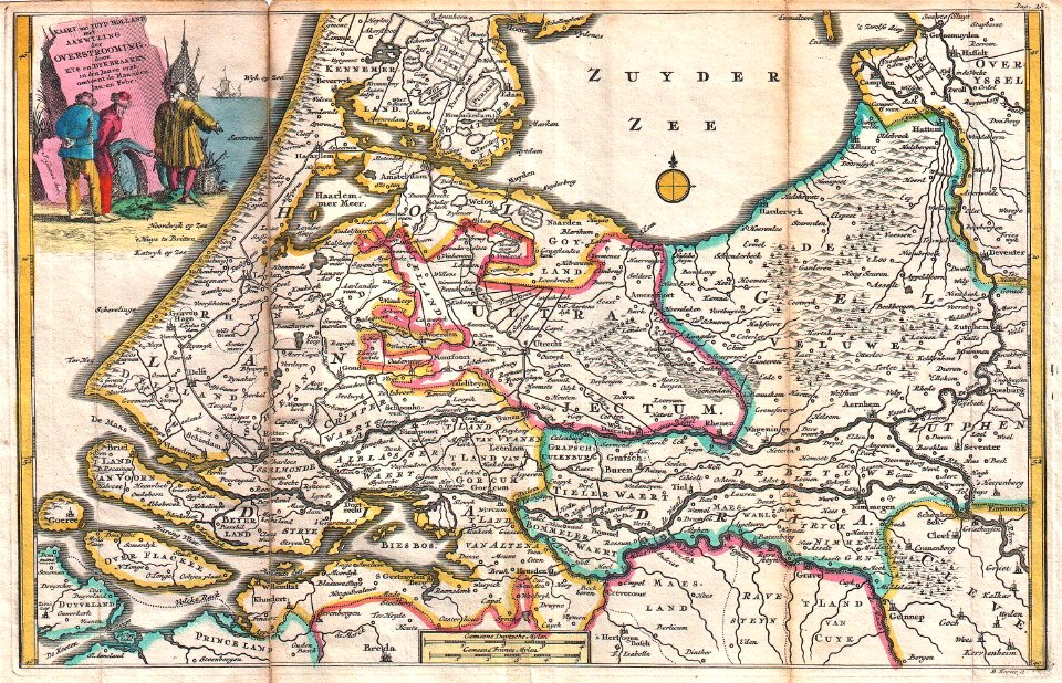
1720s maps of the netherlands
1726 maps
the hague in the 1570s
siege of leiden
gemeente atlas van nederland - south holland
polytechnische school te delft
midden-delfland in the 18th century
maps of midden-delfland
nicolaas samuel crucquius
old maps of delfland
maps by christian sgrothen
old maps of utrecht
maps of polders in south holland
old maps of delfland
maps of polders in south holland
old maps of delfland
maps by willem and johannes blaeu
old maps of gouda
atlas der neederlanden deel ii: holland 1. zuid-holland
maps from university of amsterdam special collections
gemeente atlas van nederland - south holland
maps of alkemade
gemeente atlas van nederland - south holland
maps of moerkapelle
gemeente atlas van nederland - south holland
maps of nieuwerkerk aan den ijssel
old maps of katwijk, south holland
brittenburg
cornelius aurelius world map
1510s maps of south america
gemeente atlas van nederland - south holland
maps of kethel en spaland
gemeente atlas van nederland - south holland
maps of oudewater
media from regionaal archief alkmaar
zuidschermer
media from regionaal archief alkmaar
scharwoude
maps of polders in south holland
old maps of the hague
gemeente atlas van nederland - south holland
19th-century maps of rotterdam
gemeente atlas van nederland - south holland
maps of zevenhuizen
gemeente atlas van nederland - south holland
old maps of delft
maps of polders in south holland
old maps of westland
17th-century maps of zeeland
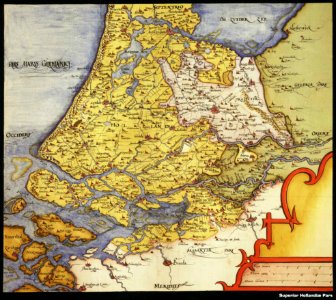
old maps of south holland
maps of waterways in the netherlands
maps of nieuwe merwede
maps of polders in south holland
17th-century maps of rotterdam
sion, quarter of rijswijk
1712 maps
gemeente atlas van nederland - south holland
de lier
nicolaas samuel crucquius
old maps of delfland
old maps of south holland
atlas novus (blaeu)
gemeente atlas van nederland - south holland
maps of alblasserdam
maps of the world with orthographic projection
maps of the world without antarctica
locator maps of the harbour of rotterdam
maps of scheepvaartkwartier
locator maps of the harbour of rotterdam
glashaven (canal in rotterdam)
101 - 200 of 251
Next page
/ 3